Showing posts with label Trail. Show all posts

15 June 2010

More from Sri Pada


This picture was taken from the top of Sri Pada. The twin peaks are known as Bena Samanala.

As you may know, there are few routes to reach the top and the local letters in the picture directs you to Rathnapura, Palabaddala route. The same route will take you to Kuruwita, Erathna road as well as Maliboda route. The other route at the top is Hatton, Nallathanni route. Moraywaththa Trail also linked with Nallathanni route.

The complete set of photos taken from the summit of Sri Pada is uploaded here.

08 February 2010

Kunudiya Parvathaya


This monarch of a rock is one of the prominent sights from the top of Sri Pada. Those who travel from Palabaddala or Kuruwita will see many of its colossal elevations along those trails. Its singular appearance is further buoyed by its tremendous precipice.

This mountain, known as Kunudiya Parvathaya is situated within the peak wilderness area, west of Sri Pada. It juts out from the low country in one sheer, unbroken slope, to a height of over 5,000 feet above sea level. During the sun rise, the shadow of the Sri Pada Mountain could be seen hovering over this mountain like a gigantic triangular silhouette.

29 January 2010

Hiking Trails in Maningala


Hope you remember the parts of hiking trails, I brought to you in different posts;

Today I’m bringing you another interesting part of the hiking trail on the way to Maningala.

Please click here to see more similar images from the same trail.

11 January 2010

Creeper


This interesting creeper was found in the middle of the trail to Mulawella. These types of creepers are in abundance in this primeval forest.

More interesting things were in store in this trail, all the way up to the mountain.

07 January 2010

Mulawella


During my recent visit to Sinharaja rainforest, I climbed Mulawella mountain, which is one of the highest points in the reserve. This peak is about 2500 feet high and it is one of the easier trails in Sinharaja. The round trip trail from the entrance of the forest reserve and back is about 6 - 7 kilometers.

The view from top of Mulawella is one of the best you can ever get within Sinharaja. I shall upload more pictures soon.

05 January 2010

Edanda


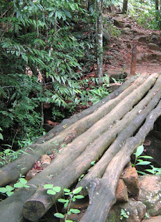
This is called ‘Edanda’ in Sri Lanka. It may be one of the most elementary methods of bridge building, yet it serves the purpose. You will come across similar bridges, in most of the footpaths in Sri Lankan villages.

The above Edanda was captured on my way to Kabaragoi Ella.

24 December 2009

Sri Pada Mountain


This iconic conical peak is the most sacred mountain in Sri Lanka. It is known by several names like Sri Pada (holy foot print), Siri Pada, Samanala Kanda (Butterfly Mountain) and Adam’s Peak.

The mountain is visited and worshipped by all communities of Sri Lanka as well as foreigners. Buddhists believe that the Lord Buddha once came to the top of this mountain and marked his sacred foot print. Similarly Hindus believe Lord Shiva has set his foot at the same place. Also there is a belief that Adam, the first man on earth set his foot there after he was exiled from the Garden of Eden.

The mountain is about 7300 feet tall and is one of the highest mountains in Sri Lanka. More importantly it has the highest ascend out of all mountains in the country. The climb is around 3000 feet from the foot of the mountain to the summit.

Every year thousands climb to the top to worship the sacred foot print and earn blessings. The Siri pada pilgrimage season starts from December full moon day and ends in April. The off season is usually rainy and it is not the best time to climb the mountain.

The mountain is situated in the western perimeter of the central highlands in the middle of a thick rain forest known as Samanala Adaviya or Adam’s Peak Wilderness Area. It is the principal peak of the Samanala mountain range. The range and the surrounding forest are famous for its rich biodiversity as well as breathtaking natural beauty.

One of the most fascinating sceneries is the sun rise from the top of Sri Pada. Lot of people climb Siri Pada at night to witness this charming cynosure popularly known as, 'Ira Sevaya'.

There are quite a few foot trails leading up to the mountain. Some are quite famous and some are known to villagers and experienced hikers only. I have tried four of the trails and completed three so far. Maliboda trail was tried and failed miserably. The first three mentioned below are the popular ones.

• Rathnapura, Palabaddala Trail – this is the oldest and most celebrated trail to Siripada. This 9km trail consists of the famous waypoints like Lihinihela , Geththampana, Dharmaraja Gala and Seethagangula.
Hatton, Nallathanni Trail – This is one of the shortest and the easiest trails. Hence the majority of the devotees take this route nowadays. The trail is about 6 km.
• Kuruwita, Erathna Trail – The longest and one of the more difficult trails. The entire length is around 12km. This joins with Ratnapura trail about 2 kilometers before the peak at a place called ‘Heramitipana’. This is the third most famous trail.
Maliboda Trail – This is one of the more difficult paths. The entire length is around 12km. Starts from Uda-Maliboda village off Deraniyagala and joins Kuruwita route.
• Moraywaththa Trail – The shortest trail to the peak starting from Moray estate, off Maskeliya. It joins Nallathanni path just before Mahagiri dambaya after Indikatupana. The entire trail is around 5km.
• Mukwaththa Trail – This is another not so famous track. The trail is about 7-8 km.

The above picture of Siri Pada Mountain was taken from Moraywaththa trail (at a place called Sandagalathenna). I will bring detailed accounts of the above trails later.

Please visit this site to learn more about Siripada - www.sripada.org

28 November 2009

Other Side of the Trail


This is the continuation of my previous post about Maningala trail. So for those who are not in a position to explore Maningala trail any sooner, I’m posting what is stored for your eyes, just as you walk a few steps along this trail.

You can see this spectacular view, halfway towards the top of Maningala. The village below is Etanwela. Also you can see part of Pitawalapathana towards the top right hand corner. The mountain range is Knuckles.

So now you have seen what is on the other side of the trail.

26 November 2009

The Trail


This interesting picture was taken during my recent hike to Maningala. The trail to Maningala is one of the best nature trails I have walked and it takes you through one of the most scenic areas of Sri Lanka.

Don’t you like to walk along this trail and see what is on the other side?

17 October 2009

Maningala


This magnificent nature trail is situated in the Knuckles Range. Maningala is a flat, long, rocky outcrop somewhat shaped like a reclining elephant. It is situated just behind Etanwela village and the ledge spread North East towards Illukkumbura. Usually you can see this mountain clearly on your right hand side while you descend towards Illukkumbura passing Riverston along Pallegama Road.

You can either start the hike from Illukkumbura or you may do the reverse from Etanwela. The actual path is starting from the Forestry Department Office of Illukkukmbura, but Etanwela path is easier to climb. The reason is Etanwela situated about 500 feet above Illukkumbura. The entire trail is about 6km long and the total climb is less than 1500 feet.

A traveler has to turn from the Pallegama Road and travel towards Rathninda village. Then you have to start walking at the boundary of Rathninda and Etanwela village. First you have to cross the beautiful Thelgamu Oya over a foot bridge and then enter Etanwela village.

The trail is not a difficult one. Although the rocky outcrop looks absolutely sheer and imposing, the trail takes you via a less steep path. In fact this is the foot path used by the villagers to reach Illukkumbura area. There are not many steep hills and the path is quite clear with no under growth and also there are arrows marked at all uncertain places. But you may need to ask the path from the villagers during the first stage as there are many similar paths leading to a few other places. (E.g. Meemure, Kalupahana, Rambukoluwa, Walpolamulla etc.)

At the top of Maningala you will see one of the most spectacular sights of Sri Lanka. There is a flat surface before the summit point (the head of the elephant) and it is at least about the size of a football ground. From there you can see most of the prominent places in the Knuckles Range like Thunhisgala or Kalupahana, Pitawalapathana, Karagahathenna, Riverston, Gammaduwa etc. The top of Maningala is quite windy. The descend towards Illukkumbura is equally pleasant as you can see the vast land up to Batticaloa, Trincomalee and even the North Western area. When you descend further down you will see the beautiful Illukkumbura village.

To learn more about this nature trail, you can visit this wonderful site, Lakdasun.

The above photo was taken from Etanwela village. You can view photos taken from top of Maningala in my next two posts, here and here.

02 July 2009

Mountain Trails


This picture was taken at a place close to Haldummulla on the way to Haputhale. The mountain and the surrounding are quite scenic especially with the mist coming from one side.

This area is a great place for hikers as there are endless hiking routes connecting many places. You may find lots of streams, waterfalls and hills along these paths. Climate is also very soothing, not so cold not so warm.

17 March 2009

Path Finding Tips


When you walk in the jungle or lonely paths there is a high possibility of getting lost. I have jotted down some simple tips that may help to reduce that risk.

1. Never walk after dusk in jungles or where there are no villagers.
2. Always keep a track of streams that you pass by.
3. Whenever you had to move out of a footpath always look ‘behind’ and try to keep a track of all the significant landmarks you pass by.
4. Try to keep a map of the area, before you embark on your hike.
5. Get hold of a good compass and estimate the directions and your location.
6. Learn some of the navigational methods like triangulation.
7. If you have a GPS it is easy. Just mark the coordinates where you start the hike.

I have lost my way quite a few times but some of the above practice has helped me to get back on my track.

To view more on hiking guidelines click here and here.

29 January 2009

Ohiya to Kalupahana via Devil's Staircase


This is an exciting hike route which takes an entire day but I would suggest readers to take more than one day for this route and try camping out for one night. This will give more time to enjoy the hike and to admire the breathtaking beauty all the way down.

The entire track is about 20km. There is a road (Actually 4WD or Jeep track) from Ohiya railway station to Kalupahana on the A4 road. This is the same road you travel from Ohiya to Horton Plains but there is a 'Y' junction after about 5km. The upper road goes to the plains and the lower road directs you to Kalupahana via Udaveriya Estate.

At Udaveriya you will come to the infamous 'Devils Staircase' (Yakage Padipela in Sinhala) which has a very steep descend. You can cut across tea estates and explore short cuts but you have to be careful not to lose your path. In the process you will come across number of small streams of water which are actually small tributaries of Belihuloya. You can camp either at Udaveriya or further down closer to Kalupahana. I once camped on top of Bambarakanda falls and that was an experience of its own!

The view throughout the hike is simply amazing and I particularly prefer the wonderful sight of Bambarakanda falls and the panaromic view of the hills with entire Southern Province in the background!