Showing posts with label Historical Importance. Show all posts

26 January 2011

The Mountain


This is how Adam's Peak looks from the trailhead of Nallathanni route. The total distance to the top is about 6km.

03 January 2011

Ira Sevaya


I climbed Adam's Peak on the New Year Day and was on top of the mountain on the 2nd morning.

Even tough I had climbed the mountain several times; I had never seen the phenomenon known as 'Ira Sevaya' - Service of the Sun. This time I was very lucky to see this dramatic display of the rising sun.

Ira Sevaya is the rise and fall of the sun just before the sun rise. People believe that the sun is worshipping the mountain. Actually this is a natural occurrence that could be seen from other places too. Due to the unique location of the mountain and the altitude of the mountain top, there is a better possibility of seeing this natural effect from Adam’s Peak than other places. This natural effect is explained very well in this article here.

It was a rainy day on the 1st and it was very misty through out the climb. We were at the top by 5am and the entire mountain was covered with thick clouds. So we had very little expectations of seeing the sunrise. But suddenly around 5.30, just before the sunrise, the clouds and the thick mist cleared out and we were very fortunate to see this fantastic display of sun rise.

06 August 2010

Eight Meter Door Frame


This colossal granite door frame was seen in the ancient capital of Anuradhapura.

Anuradhapura is a UNESCO World Heritage site and it has thousands of ruins scattered in an area as large as 40 square kilometers, belong to the period from 4th century BC to 11th century AD.

This particular building must have built over one thousand years ago as it belongs to the latter Anuradhapura period.

15 June 2010

More from Sri Pada


This picture was taken from the top of Sri Pada. The twin peaks are known as Bena Samanala.

As you may know, there are few routes to reach the top and the local letters in the picture directs you to Rathnapura, Palabaddala route. The same route will take you to Kuruwita, Erathna road as well as Maliboda route. The other route at the top is Hatton, Nallathanni route. Moraywaththa Trail also linked with Nallathanni route.

The complete set of photos taken from the summit of Sri Pada is uploaded here.

03 May 2010

Trees in the Lake


Above interesting photo was taken from the tank bund of Thisa Wewa (Tank) of Thissamaharama. Thisa wewa is one of the most scenic places in Sri Lanka. I’ll prove it with some pictures soon.

Thissamaharama is a town south of Sri Lanka situated in a vital location. Some of the facts are mentioned below.

The main temple of Thissamaharama is one of the 16 sacred places of Sri Lanka for Buddhists. In addition there are number of important places with archaeological importance. Thissamaharama is very close to culturally important venue of Katharagama, where people from all religions and race come to worship throughout the year. Also it is the closest town to the southern entrance of Yala National Park.

07 April 2010

Yala National Park


Yala is a small area in the south east coast of Sri Lanka . The name ‘Yala’ is well-known as Sri Lanka’s most famous and the second largest national park (Ruhunu National Park) is given the same name. In fact Yala is a part of the park itself.

Yala is situated about 300 km from Colombo . The park is about 1000 square kilometers and it spreads in three districts (Hambanthota, Monaragala and Ampara) belong to three provinces.

The southern part is known as Block 1 and it is the more popular section. The entry point to this section is situated at Palatupana. Nimalawa sanctuary is situated adjacent to this entry point. Western and Northern Parts, belong to Uva Province, are comprised of Yala Blocks 3, 4 and 5. Kataragama and Katagamuwa sanctuaries are situated in the west, adjacent to the park. The eastern part of Yala, belongs to Eastern Province is now known as Kumana National Park. This was recently opened to the public after many years of isolation due to security reasons.

Yala is more famous for its fauna than flora. Elephant, leopard and bear sightings are regarded as prized ones while deer, crocodiles, wild boar and wild buffalos are quite common sights. It is also a paradise for birders.

Yala is situated in the dry zone of Sri Lanka. The jungle is mostly made of dry monsoon forests, thorny forests and grasslands. Among the larger varieties, Palu trees are quite common. This area gets water from two main rivers (Kumbukkan Oya and Menik Ganga), but those also run dry during dry seasons. A few tanks in the park keep all the animals alive during dry periods. One prominent tank is Butawa Wewa, which is known as the last water resource that remains even during heavy draughts.

Yala is famous for its historical significance as well. Quite a few ancient ruins are scattered in these areas and some are yet to be discovered. There are a few prominent temples situated within this park. Sithul Pahuwa is the most famous temple which is situated on top of a rocky outcrop. There are a few more rocky outcrops in the park and some of the more prominent ones are Akasa Chethiya (Elephant Rock), Jamburagala and Pimburagala.

The Indian Ocean is the southern boundary of Yala and it has some of the most beautiful and unique beaches in Sri Lanka like, Patanangala, Kumana and Minihagalkanda.

Yala is one of the must-go-places in Sri Lanka and I shall bring more about this place soon.

This post was selected for Kottu Section of week end news paper, The Sunday Leader.

19 March 2010

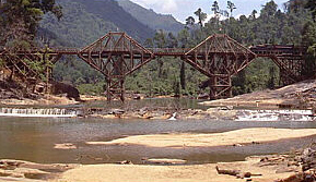
The Bridge on the River Kwai


Hope some of you may remember the award winning film in the 1950’s – The Bridge on the River Kwai.

Although the plot was set in Thailand, most of it was filmed in Kithulgala, Sri Lanka. The most important part of the film, the bridge was built across River Kelani instead of River Kwai. There is no bridge here today, but you can still see some of the reminiscences of the temporary bridge built just for the film. The above picture shows a recent image of the exact location where the bridge was built in 1957. I have added more pictures of this place here .

You can reach this place via Avissawella - Nuwara Eliya Road (A7). Just before Kithulgala Town, you have to turn to your right and walk along a foot path about a kilometer to reach this place.

24 December 2009

Sri Pada Mountain


This iconic conical peak is the most sacred mountain in Sri Lanka. It is known by several names like Sri Pada (holy foot print), Siri Pada, Samanala Kanda (Butterfly Mountain) and Adam’s Peak.

The mountain is visited and worshipped by all communities of Sri Lanka as well as foreigners. Buddhists believe that the Lord Buddha once came to the top of this mountain and marked his sacred foot print. Similarly Hindus believe Lord Shiva has set his foot at the same place. Also there is a belief that Adam, the first man on earth set his foot there after he was exiled from the Garden of Eden.

The mountain is about 7300 feet tall and is one of the highest mountains in Sri Lanka. More importantly it has the highest ascend out of all mountains in the country. The climb is around 3000 feet from the foot of the mountain to the summit.

Every year thousands climb to the top to worship the sacred foot print and earn blessings. The Siri pada pilgrimage season starts from December full moon day and ends in April. The off season is usually rainy and it is not the best time to climb the mountain.

The mountain is situated in the western perimeter of the central highlands in the middle of a thick rain forest known as Samanala Adaviya or Adam’s Peak Wilderness Area. It is the principal peak of the Samanala mountain range. The range and the surrounding forest are famous for its rich biodiversity as well as breathtaking natural beauty.

One of the most fascinating sceneries is the sun rise from the top of Sri Pada. Lot of people climb Siri Pada at night to witness this charming cynosure popularly known as, 'Ira Sevaya'.

There are quite a few foot trails leading up to the mountain. Some are quite famous and some are known to villagers and experienced hikers only. I have tried four of the trails and completed three so far. Maliboda trail was tried and failed miserably. The first three mentioned below are the popular ones.

• Rathnapura, Palabaddala Trail – this is the oldest and most celebrated trail to Siripada. This 9km trail consists of the famous waypoints like Lihinihela , Geththampana, Dharmaraja Gala and Seethagangula.
Hatton, Nallathanni Trail – This is one of the shortest and the easiest trails. Hence the majority of the devotees take this route nowadays. The trail is about 6 km.
• Kuruwita, Erathna Trail – The longest and one of the more difficult trails. The entire length is around 12km. This joins with Ratnapura trail about 2 kilometers before the peak at a place called ‘Heramitipana’. This is the third most famous trail.
Maliboda Trail – This is one of the more difficult paths. The entire length is around 12km. Starts from Uda-Maliboda village off Deraniyagala and joins Kuruwita route.
• Moraywaththa Trail – The shortest trail to the peak starting from Moray estate, off Maskeliya. It joins Nallathanni path just before Mahagiri dambaya after Indikatupana. The entire trail is around 5km.
• Mukwaththa Trail – This is another not so famous track. The trail is about 7-8 km.

The above picture of Siri Pada Mountain was taken from Moraywaththa trail (at a place called Sandagalathenna). I will bring detailed accounts of the above trails later.

Please visit this site to learn more about Siripada - www.sripada.org

14 November 2009

Thanthirimale


This ancient and sacred temple is situated in a remote place about 35 kilometers north west of Anuradhapura. It is situated on top of a rocky terrain. Thanthirimale is definitely a larger temple but it surely reminds Buddhangala Temple of Ampara.

As per the historical evidence this area is one of the oldest human settlements in Sri Lanka which dates back to pre 6th century BC. Also it is mentioned in many historical chronicles as a pivotal place all throughout the history.

The Bo tree here is said to be at least 2300 years old. It is a direct sapling of the famous Sri Maha Bodhi of Anuradhapura.

I’m not going to give detailed explanation about this place as Harumi has done a few wonderful narratives about this place. You can see those posts here, here and here.

The view from this wonderful hermitage is stunning. The above picture shows the granite Buddha statue which dates back to 8th century AD. I have uploaded more pictures of this wonderful place here.

20 September 2009

Taprobane to Ceylon


Sri Lanka has a long history and most prominently it has one of the longest written histories in the world. Throughout the time Sri Lanka was known by many names by different countries and historians.

The king Vijaya, a prince from Wanga Desha (probably West Bengal) named this land, ‘Thambapanni’. Subsequently he became the first recorded king of the island. As per the chronicles he landed here in 543 BC.

Later in the 2nd century AD, the Greek mathematician, Ptolemy marked this country as ‘Taprobane’ in his famous world map. The Taprobane he mentioned was quite bigger, yet the unmistakable location clarifies that he wanted to show Sri Lanka in the map.

Later on, the Arab merchants (as well as Persians) used to call this country as ‘Serendib’. Also there are records that Chinese called Sri Lanka as Si-Lan. The 14th century explorer Marco Polo, visited Sri Lanka and he went on to record that he found many pearls and precious stones in the Island of Seylan.

Since, 16th century AD, many European nations ruled Sri Lanka partially and later on the British controlled the entire country for more than a century (1815 – 1948). The Portuguese the first of the European nations who invaded, called the country Celao and subsequently Zeilan by the Dutch. The British named this island as Ceylon and it was used during major part of the 20th century until it was officially changed to ‘Sri Lanka’ in 1972.

To read more about Sri Lanka click here.

The picture above shows a moonstone, a typical stepping stone found in many Sri Lankan temples. To learn more about them read this post by Harumi.

15 September 2009

Kala Wewa


This beautiful tank, Kala Wewa is situated in the North Central Province. You can reach here on your way to Anuradhapura (via Dambulla) by turning off at Kekirawa town.

Kala wewa was built by the King Dhatusena in the 5th century AD. In fact the King built another tank (Balalu) adjacent to this one and the two tanks are joined to form one of the biggest tanks in Sri Lanka (Kala - Balalu wewa)

There are many interesting places to visit close to this area. Some of the key places are mentioned below.
Aukana buddha statue - A standing buddha statue date back to the same period as the tank. The statue is situated by the side of the tank
• Jaya Ganga - An ancient canal that link Kala Wewa and Thisa Wewa of Anuradhapuara.

The above picture was taken from the bund of the tank, which I mentioned in one of my earlier posts.

04 September 2009

Kirinda Beach


This is a similar beach to the one I posted a few days back. The difference may be that this one is more popular and you may see lots of visitors here every day.

Kirinda, is situated South of Sri Lanka close to Yala National Park. This is a popular beach venue for thousands of devotees who go on pilgrimage to Katharagama – The place of worship, South of Sri Lanka where all Sri Lankans visit so religiously regardless of their religion or creed.

There is a small temple in this place on top of a medium size rock outcrop facing the sea. As per the historical chronicles, a princess was sacrificed to the sea to prevent a catastrophic sea wave (Tsunami?) that destroyed the land in the Western coast of Sri Lanka more than 2000 years ago. To some extra ordinary reasons the sea wave was immediately suppressed and this princess survived and landed back at a remote beach South of Sri Lanka. People believe Kirinda is that historical place, where this princess landed safely. Subsequently this brave princess became famous as Queen Vihara Maha Devi.

This beach is one of the most attractive beaches in the Southern coastal belt.

21 July 2009

Buddhangala


Sri Lanka is full of temples and monasteries. Some temples in places like Anuradhapura are older than 2000 years. In addition to the famous temples in main cultural towns like Anuradhapura, Kandy and Polonnaruwa, we find many important temples all around the country. These temples are full of devotees throughout the year. One interesting feature is that we find many outstation temples located in rocky outcrops. One good example is Dambulla. These locations give the temples, an elevated position compared to the rest of the buildings and they become visible from distant places.

Above picture and some more here were taken at this very interesting buddhist temple called Buddhangala Aranyaya (Hermitage) about 8 kilometers from Ampara. The temple is situated in a very peaceful location on top of a rocky outcrop which is about 450 feet high.

You can see a panoramic view of the region from the top. Ampara town, Galoya valley and Inginiyagala area can be seen very clearly. Please visit this web site to find more information about this monastery.

30 June 2009

The Cave


This cave known as Fa Hien (Pahiyan Lena) is possibly the largest cave in Sri Lanka. It is situated in the village called Yatagampititya in Kaluthara District. You can reach here via Piliyandala – Horana road and it lies about 5 kilometres from Bulathsinhala.

This cave can easily shelter 1000 men and the cave entrance is at least 50m in height and 60m in length.

Fa Hien's cave is famous for two reasons. Firstly, Sri Lankan archaeologists found evidence of human existence date back to thousands of years in this area. Usually we do not get any written records related to this era so archaeologist have named this period as pre-historical period. Dr. Shiran Deraniyagala the former Director General of the Department of Archaeology was instrumental in discovering this very important evidence from this cave as well as many other locations in Sri Lanka. In this cave, they have found a few human skulls and bones dating back to 35000 years and lots of man-made tools used for hunting animals and various other purposes.

The second reason is that Fa Hien, the famous Chinese Monk of the 5th century AD, who came to Sri Lanka in search of Buddhist scriptures and sacred places used to stay in this cave for some time on the way to Sri Pada (Adam’s Peak). Hence the cave got his name - Pahiyan Lena (Cave)

There is a road leads very close to the cave so you do not need to do much walking. There are similar caves mostly in Sabaragamuwa District which are quite famous for pre-historic evidence of human existence. Batadomba Lena in Kuruwita and Beli Lena in Kitulgala are some of them. The trails to these caves are even more interesting.

28 January 2009

Arankele Monastery


There are hundreds of monasteries all over the country where buddhist monks live closer to the nature practising meditation.

Anyone can visit such places, but you have to observe extreme silence.

One such attractive place is situated about 20km from Kurunegala town in Arankele close to Hiripitiya. There are long and straight walking paths and terraces through the forest. This place has lots of ruins of ancient buddhist temples as well.

Can there be a better place for meditation than closer to the nature?